|
The Flood of 2005
|
|
|
|
|
|
The northern Chuckery sign was in the Little Darby Creek.
|
|
The eastern Chuckery sign was in the "Chuckery Lake".
|
|
|
 |
|
 |
|
 |
|
|
|
|
|
|
|
St. Paul Lutheran Church and School sat on the northwest shore of the "Chuckery Lake" while SR 161 became the southeast shore of the lake
|
The St. Paul Lutheran Church and 
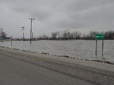
School sign became a depth marker for the "Chuckery Lake."
|
|
High water signs were posted to caution motorists on SR 161.
|
|
|
|
|
 |
|
 |
|
|
|
 |
|
|
|
|
|
Ken Rausch's dog run slowly became a part of the Little Darby Creek.
|
|
|
Walter Beachy's garage was in the Little Darby Creek.
|
|
|
Walter Burns' farm became a peninsula in the "Chuckery Lake."
|
|
|
|
|
|
|
|
 |
 |
|
 |
|
|
|
|
A small tributary of the Little Darby 
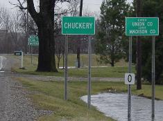
Creek formed in the ditch near the western Chuckery sign.
|
|
A pond formed near the southern Chuckery sign.
|
|
The Little Darby surrounded the old iron bridge on Rosedale - Plain City Road.
|
|
|
|
|
|
|
|
|
|
|
|
|
|
|
|
|
|
|
|
|
|
|
|
|
|